
We set sail from the port of Aix (France), on December 12, 1768, aboard the light frigate L’Isis, with 20 guns and 60 sailors on board. We were accompanied by 4 ship lieutenants, a chaplain, a surgeon and a group of trained officers who would play an active role in the scientific part. Astronomer Alexandre Gui Pingré was traveling as a delegate of the French Academy of Sciences.
The mission of the trip, sponsored by King Charles XVI, was to verify the effectiveness of the marine clocks that measured times and distances at sea, made by Ferdinand Berthoud, and in the process to establish astronomical determinations.
To test the operation of the clocks at different temperatures and eliminate possible errors in the calculations, on the way there and back we crossed the Atlantic at different latitudes, we even went twice in Tenerife.
Stay in Santa Cruz
In Santa de Tenerife we received the hospitality of the commander general Miguel López Fernández de Heredia and the French consul Mr. Cazalón, in whose house we located the observatory and fixed the position of the city at 28º 9′ 45” north latitude and 18º 36′ 0 ” western longitude with respect to the Paris Observatory. On the 28th, we headed to the Cape Verde Islands. We would make our second stopover in Santa Cruz de Tenerife on August 15, 1769, when we were coming from Madeira. That same night we observed an emergence of Jupiter’s first satellite.
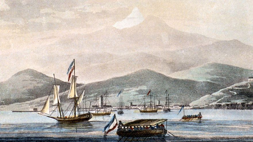
The port of Santa Cruz is the most frequented of the other three harbors that exist on the Island (La Orotava, Garachico and Adeje), as it is the only one located on the eastern coast. Its bay is formed by a chain of very high mountains that extend from east to west.
In the city, located at the foot of these mountains, there is a small dock or landing stage built with great solidity, although the surf of the sea, which is permanent on the coast, makes the rowboats suffer a lot and disembarkation is difficult.
The water is made in a fountain that is only a hundred steps from the dock, above the city fort, although there is a risk of breaking the barrels when rolling them, since the terrain is rugged and poorly paved.
Don Miguel López Fernández de Heredia, Governor General of the Islands Canary Islandsalways aware of everything that could be of some use to the colony entrusted to his charge, in order to provide facilities to foreigners who arrive there attracted by commerce, he has conceived the project of building canals that bring water to a source. which will be raised on the dock, so that the boats can be supplied without even having to unload the barrels.
The Santa Cruz roadstead is open to all winds, from the southwest and the southeast, which is why the sea is very rough, although it is safe as long as the capes hold. As the bottom decreases very quickly from the high seas to the coast, the anchors must be placed six cables from land (1,100 meters) to prevent the rocks from cutting the ropes and the boat from being lost.
Fortunately, the winds that blow from the sea do not do so for long; However, the winds that come from land are stronger and more frequent and their violence can blow boats out of the roadstead, dragging their anchors with them; Therefore, to avoid breaking the ship, the anchors must be turned towards the sea.
Expeditions that need supplies will find little supply in Santa Cruz, since since food comes from the interior of the island, it is expensive and scarce. It is mainly traded in wine, liquor and cocoa that are usually brought by return ships from Caracas or Havana, countries with which the colony has a special privilege.
We returned to Rochefort (France), on November 15, 1769, after having visited the ports of Cádiz, Tenerife, Cape Verde, Senegal, Martinique, Santo Domingo, Haiti, Newfoundland, Azores, Madeira, Tenerife – for the second time – and Cadiz.
The author of this description of Santa Cruz de Tenerife, Charles Pierre Claret de Fleurieu, was born in Lyon, France in 1738 and died in Paris in 1810. At the age of thirteen he entered the French Navy, becoming a lieutenant at the age of 21, participating in the Seven Years’ War and in the battles of Mahón, Lagos and Sabletes.
In 1762, as a ship’s second lieutenant, he was appointed inspector of the department of maps and plans of France, beginning to be interested in nautical sciences, ship construction and marine clocks, with the aim of perfecting the calculation of longitudes at sea. . In 1776, upon being promoted to captain, he would be named Director General of ports and arsenals of France and Minister of the Navy.
During his life he would hold the positions of State Councilor, Senator, Plenipotentiary Minister, Governor of the Tuileries Palace and the Louvre. In addition to being a member of the Institute of France, Quartermaster General of the Emperor’s House, Grand Officer of the Legion of Honor, etc.


