
Steps continue to be taken to extinguish the Tenerife fire that broke out on August 15. The last one has been to go from stabilized to technically controlled after almost a month since it began
This was announced by the president of the Tenerife Cabildo, Rosa Daviladuring the extraordinary plenary session held this Monday in the island corporation to analyze the current situation of the burned soil.
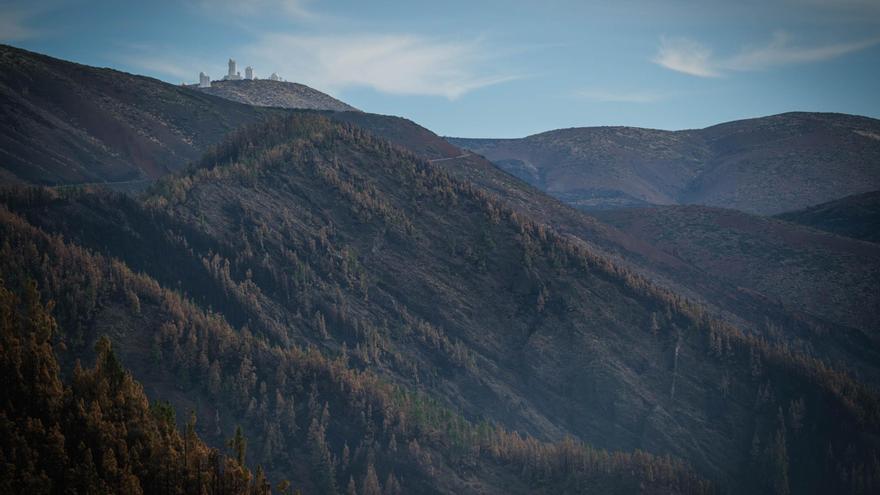
The fire affected an area of more than 14,000 hectares in a perimeter of 90 kilometers, with a total of twelve municipalities affected in the north and south of Tenerife.
catastrophic zone
This is another new step in the recovery of the mountains of Tenerife. The entire area affected by the fire has already been recognized as catastrophic zone at the beginning of the month for the Government of Spain in functions.
He Council of Ministers approved on Tuesday, September 5, declare an area seriously affected by a civil protection emergency as a result of the fires forestry to the island of Tenerife along with several areas in the autonomous communities of Andalusia, Castilla and LionCastilla-La Mancha, Foral Community of Navarra, the Valencian Community and Extremadura.
Work continues
Despite the good news about the evolution of the fire, the extinguishing and protection teams, above one hundred troopscontinue working on the affected areas in order to declare the fire extinguished, the last step that remains.
During the last weeks, the Tenerife Cabildo has had to ask responsibility to several people who have traveled through affected areas by flames when it is strictly prohibited to do so.
Other measures
The ban on the use of fire outdoors is maintained (bonfires, stoves, barbecues, gas stoves) and pyrotechnic displays in the area that is within the Corona Forestal Natural Park of the municipalities affected by the fire.
In the rest of the areas of the municipalities affected by the fire, the use of machinery and tools is permitted, although extreme caution is requested when using them. Likewise, hunting activity is allowed.
Access to National Park Teide it is still closed by the TF-24 (La Esperanza) and the TF-21 (La Orotava). Access can be made through Vilaflor (TF-21) and Chío (TF-38). The cutting point is located in Portillo Alto so that people can access the restaurants that are located in the area.
Road TF-523 (Los Loros Climb) It also remains closed. However, the cut-off points of the TF-21 (La Orotava) and the TF-523 (Subida Los Loros) in order to facilitate access to the farms. Thus, in the TF-21 the cut-off point is located at the station. 16+500, at the height of La Caldera, where the barrier preventing passage will be placed. On the TF-523 road (Subida Los Loros) the cut is located at Pk. 13+500 between 8:00 a.m. and 8:00 p.m. (daytime). At night, the cut will be located in the PK. 10+100, where the barrier will be placed to prevent the passage of vehicles.
On the other hand, the following recreational areas and camping areas are temporarily closed: Chanajiga (Los Realejos), Hoya del Abade (La Victoria), La Caldera (La Orotava), La Laguneta Chica (Santa Úrsula), Las Calderetas (El Sauzal), Las Raíces (El Rosario), Lomo La Jara (Tacoronte), Los Frailes (Arafo) and Ramón El Caminero (La Orotava).
As for the walking trails of the Teide National Park, the following are completely closed: Trail no. 1 La Fortaleza, Trail no. 2 Arenas Negras, Trail no. 8 El Filo, Trail no. 14 Alto de Guamaso, Trail no. 17 Igueque, Trail no. Fasnia, Trail No. 21 Corral del Niño to La Yegua Blanca, Trail No. 25 Recibo Quemado, Trail No. 29 Degollada del Cedro, Trail No. 34 Montaña Limón, Trail No. 36 Alto de La Fortaleza and Trail No. 37 Cerrillar-Carnicería.
For its part, Trail No. 4 Siete Cañadas is partially closed: from the beginning at the El Portillo Visitor Center to its contact with Trail No. 30 Los Valles (Risco de La Papelera), while Trail No. 22 Lomo Hurtado is partially closed from the beginning in contact with trail nº1 La Fortaleza until its contact with trail nº33 Montaña Negra).


