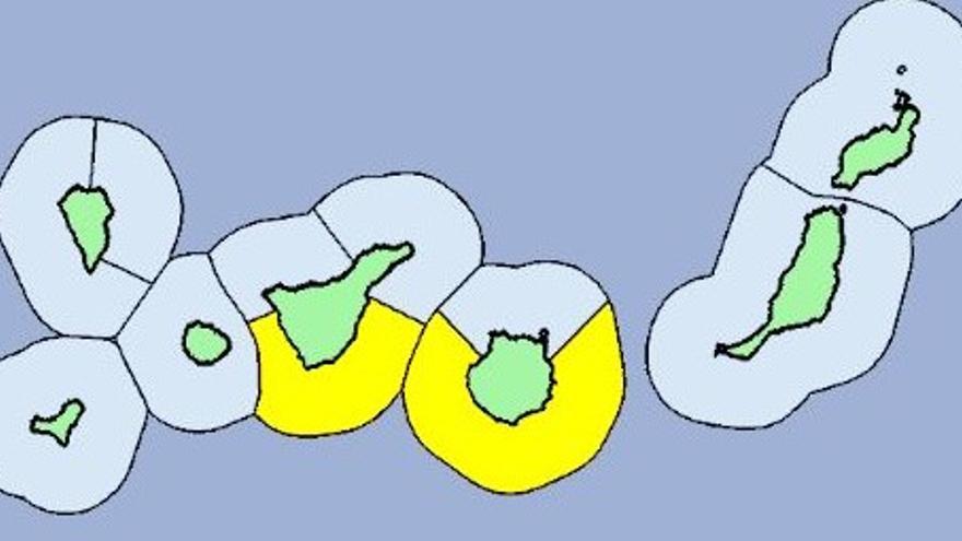
The force 7 wind will be especially noticeable in the channel between the capital islands, that is, on the southeast coast of Tenerife and the west of Gran Canaria, details the General Directorate of Security and Emergencies of the Government of the Canary Islands.
In this way, we must be very careful with people who approach the sea during the next two days, which are not work days in the Canary Islands and that many residents and tourists take the opportunity to take a bath.
On the other hand, according to the Aemet in Canary Islands the wind will blow from the moderate to strong northeast more intensely in Lanzarote Y on slopes exposed to the trade winds on the more prominent islands. are not discarded punctually very strong streaks in the inland areas of Lanzarote, the south of Fuerteventura (Jandía), the peaks and southeastern and western slopes of Gran Canariathe southeast, extreme northwest and high areas of the northeast slope (Candelaria and El Rosario) of Tenerifethe east and northwest slopes, as well as on summits of La Gomerathe extreme southeast and northwest and summits of The Palm and the southeastern and western slopes and summits of The iron.
The prediction by islands for tomorrow, Holy Thursday, in the following:
Lanzarote
Cloudy skies, tending to slightly cloudy in the afternoon. Temperatures with little change. Moderate to strong northeast wind, without ruling out very strong gusts in interior areas, especially during the second half of the day.
Minimum and maximum temperatures in Arrecife 15 23
Fuerteventura
Cloudy skies, tending to slightly cloudy from midday. Temperatures with little change. Moderate to strong northeast wind, more intense on the western and eastern slopes, as well as in Jandía, where very strong gusts are not ruled out, especially during the second half of the day.
Minimum and maximum temperatures in Puerto del Rosario 17 23
Gran Canaria
In the north, cloudy or covered skies, with a low probability of light, occasional and scattered rains in the midlands during the first half of the day. In the rest, cloudy intervals tending to slightly cloudy or clear. Temperatures without changes or with a slight decrease in the maximum in interior areas. Moderate to strong northeast wind, more intense on the southeast and west slopes and in the midlands and high areas of the southern half, where locally very strong gusts are not ruled out, more likely during the second half of the day. Breezes on the southwest coast.
Minimum and maximum temperatures in Las Palmas de Gran Canaria 18 21
Tenerife
In the north and northeast, cloudy or covered skies tending to cloudy intervals in the afternoon, except in the extreme northeast, with a low probability of weak, occasional and scattered rains in the middle in the early hours. In the rest, cloudy intervals tending to slightly cloudy or clear. Temperatures without changes, except for slight increases in central peaks and slight decreases in the maximum in the northeast midlands. Moderate to strong northeast wind, more intense in the middle and high areas of the northeast slope, on the southeast slope and in the extreme northwest, where locally very strong gusts are not ruled out, more likely during the second half of the day. In central summits, north component wind, which in the early morning will tend to the northeast. West coast breezes.
Minimum and maximum temperatures in Santa Cruz de Tenerife 17 22
The Palm
In the north and northeast, cloudy or covered skies tending to cloudy intervals in the afternoon, except in the extreme northeast, with a low probability of weak, occasional and scattered rains in the middle in the early hours. In the rest, cloudy intervals tending to slightly cloudy or clear. Temperatures without changes or in slight decrease, especially in high areas. Northeast wind, with strong intervals at the summits and extreme southeast and northwest, where locally very strong gusts are not ruled out, more likely during the second half of the day. West coast breezes.
Minimum and maximum temperatures in Santa Cruz de La Palma 16 21
La Gomera
In the north, cloudy or overcast skies, with a low probability of light, occasional and scattered rains in the midlands in the early hours. In the rest, cloudy intervals tending to slightly cloudy or clear. Minimum temperatures with few changes and maximum in slight decrease. Moderate to strong northeast wind, more intense on summits and east and northwest slopes, where locally very strong gusts are not ruled out, more likely during the second half of the day. Breezes on the southwest coast.
Minimum and maximum temperatures in San Sebastián de La Gomera 18 22
The iron
In the north and northeast, cloudy or covered skies tending to cloudy intervals in the afternoon. In the rest, cloudy intervals tending to slightly cloudy or clear. Minimum temperatures with few changes and maximum in slight decrease. Moderate to strong northeast wind, more intense on the summits, southeast slope and extreme west, where locally very strong gusts are not ruled out, more likely in the second half of the day. Breezes on the southwest coast.
Minimum and maximum temperatures in Valverde 12 16


