
SANTA CRUZ DE TENERIFE, Oct 26 (EUROPA PRESS) –
The National Geodetic Reference Network of Permanent Stations (GNSS) installed on the island of La Palma has detected in the Los Llanos station (LP10), the closest to the cone, an increase in deformation in the last 24 hours of up to 10 centimeters that has not been observed in the stations furthest from the eruptive center, where a slight regional deflation of deep origin persists.
The director of the National Geographic Institute (IGN) in the Canary Islands and spokesperson for the Pevolca Scientific Committee, María José Blanco, indicated that this pattern has already occurred on two occasions, one in September and another around October 12, and they were followed by an intensification of the phenomena observable in the eruptive centers, such as an increase in the flow of lavas and the opening or closing of emission centers that were in the cone.
María José Blanco indicated that this would be observable but the veracity of this deformation must be corroborated, as it could be an erroneous value. For this reason, an observation campaign will be intensified along the road that goes south to be able to corroborate the magnitude of this deformation as it is not observed in the rest of the network of stations installed on the island.
The spokesperson pointed out that this elevation of the surface could be the consequence of an increase in the accumulation of magmatic material just below the Los Llanos station and at surface levels and insisted that the increase in flow and the opening or closing of eruptive centers would be what expected in the next few hours.
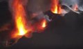
The technical director of Pevolca, Miguel Ángel Morcuende, reported at a press conference that the reconfiguration of the volcanic cone continues, with lava emission to the west, descending on the previous flows, mainly on the original wash (number 1) and on which It runs above the Todoque mountain (number 4).
Miguel Ángel Morcuende added that these new lava flows run under the oldest lava flows through lava tubes and also on the surface, filling in islands that in previous days were still emerging or had their surface untouched.
María José Blanco specified that the morphology of the cone changes repeatedly due to the successive processes of growth and reconfiguration and yesterday, around 8:00 p.m., there was an increase in the lava lake that produced the partial collapse of the upper part of the cone, dragging large blocks.
HIGH MAGNITUDE.
Regarding seismicity, it continues to be located in the same area, at depths between 10 and 15 km and also at depths greater than 20 km, where the last recorded earthquakes continue to have a high magnitude although they occur less frequently than in previous days.
Likewise, high values of the amplitude of the tremor are maintained, with intensification pulses. The maximum magnitude recorded in the last 24 hours is 4.2 mbLg for an event located 36 km deep and that reached an intensity of IV EMS.
María José Blanco stated that the seismicity recorded at intermediate and deep depths is part of the current eruptive process and significant surface seismicity remains undetected. He added that the current level of seismicity continues to indicate that it is possible that more felt earthquakes may occur, reaching intensities of IV on the EMS scale.
During yesterday the emission of sulfur dioxide (SO2) associated with the volcanic plume reached 40,800 tons per day, being an underestimated value. The director of Pevolca pointed out that these figures indicate that the end of the emergency “is far away” and is one of the “clearest” indications that there is an eruption in the medium and long term. Regarding the diffuse emission of carbon dioxide (CO2) throughout the Cumbre Vieja building, there has been an upward trend, reaching 1,121 tons per day yesterday.
With regard to the lava flows, number 8 (which was heading for the La Laguna mountain) is “quite stationary” and has taken a southwesterly course to try to join with the lavage 7. However, Miguel Ángel Morcuende indicated that if there were A sufficient load of material as a consequence of the cone breakage could start its way north of the La Laguna mountain, hence this area has already been evacuated.
Colada 10, located further south, has stopped 150 meters from the photovoltaic park, 250 meters from the houses in Corazoncillo and 600 meters from the Las Manchas cemetery. There are still some islands, with Rajada Mountain as the largest island and Cogote Mountain, further south.
HOSTED PEOPLE.
The number of people housed in hotel centers is currently 452. Of these, 65 are in a hotel center in Los Llanos de Aridane and 387 are staying in a hotel in Fuencaliente. All are being cared for by the Red Cross, in coordination with the municipal social services. In addition, there are 38 dependents in insular health centers.
The area affected so far is 879.69 hectares, 27.42 more than the last day, which is mainly due to the fillings that have been registered in those islets that had been left unaffected by lava. The maximum width between casts is still around 2,900 meters and the distance to the sea for casting 7 is maintained at between 120 and 130 meters.
The buildings destroyed or damaged, according to the data provided by the Cadastre, are estimated at 1,291 buildings, of which 1,038 are for residential use, 135 for agriculture, 64 for industrial use, 30 for leisure and hospitality, 11 for public use and 14 for other uses. . According to the latest data from the Copernicus satellite, there would be 2,286 buildings / constructions affected, of which 2,162 would be destroyed and 124 at risk.


