
SANTA CRUZ DE TENERIFE, July 11 (EUROPA PRESS) –
Temperatures will drop “clearly” this Monday in the Canary Islands, although they will still exceed 32ºC in large areas of the archipelago and 35ºC in the south of Gran Canaria, says the spokesman for the State Meteorological Agency (Aemet), Rubén del Campo, which also indicates that on Tuesday they will normalize, although by the end of the week they could rise again.
In the whole of Spain, the second heat wave of the summer will be “extensive and intense”, since it will at least last until Thursday, although the State Meteorological Agency sees “quite likely” that it will continue during the next weekend and even it could reach until the first days of the next one, with days that can reach 45ºC.
Rubén del Campo has highlighted that the hottest days will be Tuesday, Wednesday and Thursday, when the maximum temperature will exceed 35 degrees centigrade (ºC) in “practically all” of the Peninsula and the Balearic Islands, except “perhaps” in areas of coast and mountains and 40ºC in large areas of the center.
In addition, he stressed that these maximums will be accompanied by very high night temperatures, which will not fall below 20ºC, that is, in practically the entire country the nights will be tropical and may even not fall below 25ºC during some early mornings in the center and the west of the Peninsula, which are considered torrid nights.
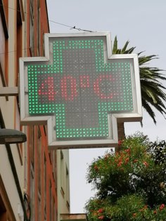
At the moment, it has indicated that the data for this Sunday, July 10, exceeded 43ºC in points of Extremadura and Castilla-La Mancha, such as in Olivenza (Badajoz), in Badajoz and in Talavera de la Reina (Toledo). ), as well as on the island of Gran Canaria. They also touched 43ºC in Agüimes and San Bartolomé de Tirajana, where it reached 42.8ºC.
In Agüimes from Saturday to Sunday there was a minimum temperature of 33.7ºC and there were minimum temperatures above 30ºC in San Bartolomé de Tirajana; in Osuna (Seville), which had a minimum of 26ºC. During the early hours of Sunday to Monday, torrid nights have also been recorded in the Canary Islands and in points in the south of the Peninsula.
For example, it has indicated that until 06:00 this Monday the minimum did not drop below 38ºC in San Bartolomé de Tirajana (Granada), 27ºC in Castuera (Badajoz).
The spokesman pointed out that the current heat wave is being produced by the presence of a ridge over the territory, that is, an area of high pressure associated with very warm air and within this ridge there are downward movements of air that in their descent they are compressed and increase the pressure and, therefore, the air heats up more.
Added to this is the very stable atmospheric situation, which prevents large air movements and favors the presence of clear skies.
As a whole, all this leads to a strong warming of the surface of the Peninsula, with a warming that is transmitted to the layer of air immediately above, which favors these very high temperatures. “This warming could be called autochthonous, since it occurs on the Iberian Peninsula itself”, he commented.
On the other hand, this Monday an air mass will arrive from the African continent that will help temperatures rise “even more”. That mass also carries suspended dust that can lead to haze with cloudy skies in the western half, especially starting Tuesday.
In short, the spokesman expects a “long” heat wave, which will last until Sunday at least and it cannot be ruled out that it will last for at least nine days. This extension would fall short of the longest 26-day heat wave to date, which took place from June 26 to July 22, 2015; or of the 16 days of the second longest heat wave that occurred between July 30 and August 14, 2003.
In any case, note that if this heat wave finally lasts nine days it would tie with the two third positions to date, which took place between July 25 and August 2, 2020 and June 13 and June 21 2017. In this regard, he recalled that heat waves have a greater impact on health due to the persistence of these high temperatures.
On the other hand, in addition to being extensive, Del Campo expects that it will also be “intense”, since from Tuesday to Thursday it could exceed 44ºC in the Guadiana and Guadalquivir valleys in cities such as Córdoba or Badajoz; 42ºC in the south of Galicia, the central area and the Ebro valley in cities such as Orense, Toledo, Logroño, Zaragoza and 40ºC in the northern plateau, in capitals such as Burgos, Palencia or Valladolid, as well as in Madrid.
On the contrary, the coolest temperatures will be in points of the Cantabrian coast, where they will reach maximums of 28 to 30ºC and in the Mediterranean, where they will be around 30 to 35ºC.
Tropical nights will be the general trend these days and even torrid nights may be recorded, especially in the center, west and south of the Peninsula.
In addition to the high temperatures, the rains will be very scarce or practically non-existent throughout the episode, although clouds of evolution will grow in isolated points of the mountains, from which an occasional shower could fall, generally weak.
In the event that these storms form, they may be accompanied by gusts of intense wind and electrical equipment, so it warns that this could cause some forest fires, since the risk will be very high or extreme in much of the territory. .


