
SANTA CRUZ DE TENERIFE, Nov. 14 (EUROPA PRESS) –
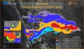
Copernicus has updated the monitoring of the La Palma volcano area, whose lava has covered a total of 1,024.4 hectares since the eruption began on September 19, affecting or destroying 2,618 buildings / constructions so far.
This is clear from the satellite data of the program dependent on the European Union according to the last mapping – number 51 – corresponding to the situation that existed this Saturday, November 13, and which reflects that in 36 hours the laundry of the The eruption had grown by 5.5 ha and destroyed 2 more buildings.
In the images captured by Copernicus, you can already see the formation of the new lava delta on the beach of Los Guirres, which has joined the fajana that created the original stream to the north and the one formed during the eruption to the south of the San Juan volcano.
The Copernicus program, coordinated through the National Center for Monitoring and Coordination of Emergencies (CENEM), has devices for the monitoring and follow-up of national alert networks, potential risk situations, incidents and emergencies in the field of civil protection.


 urges participation and admits a “good feeling” after an “intense campaign”")


