
LA LAGUNA (TENERIFE), 9 Feb. (EUROPA PRESS) –
La Laguna will recover part of the old wetland that gave its name to the city through the creation of a floodable park, a hydraulic infrastructure that, in addition to its obvious symbolic nature, will prevent future flooding in an area at potential risk of suffering them.
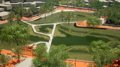
The park will be located on a plot of approximately 30,000 square meters located between Silverio Alonso, Tabares Bartlet, José Peraza de Ayala streets and Avenida de San Diego, in an undeveloped area that corresponds to part of the old wetland around which the city was founded at the end of the 15th century.
The ‘Recover La Laguna’ project was announced this Thursday by the mayor of La Laguna, Luis Yeray Gutiérrez; the Minister of Ecological Transition, the Fight against Climate Change and Territorial Planning of the Government of the Canary Islands, José Antonio Valbuena and the manager of the Teidagua mixed company, Félix de Armas.
“This is a project that will mark a before and after in this city,” said Luis Yeray Gutiérrez, who assured that he has been working for three years on the design of an infrastructure that offers “the possibility of expanding the city of a sustainable way, betting on the environment, growing to the north to have a green space, for recreation, that recovers the history of the city”.
In addition to its environmental and social value, the mayor highlighted both the hydraulic characteristics of the project, “which will solve any type of future flood problem that we may have”, as well as its symbolic value, ensuring that “it is about recovering the lagoon, the old wetland that gave the city its name and configured its idiosyncrasy”.
In his opinion, “we are recovering our identity, heritage and the pride of being from La Laguna and La Laguna, there is nothing more beautiful than leaving a legacy like the one we are going to make possible with this unique work in the Canary Islands.”
The councilor thanked the institutional collaboration and the work of the technical team that has been part of the project.
For his part, José Antonio Valbuena congratulated the La Laguna City Council for this project “which will be submitted to the Governing Council as being of regional interest, an exceptionality that does not usually occur with many initiatives in the Canary Islands and which speaks of its relevance.”
“This is not another project that is going to remain in good intentions, but rather it already has confirmed regional financing from this Ministry, with three million euros for 2023, and whose protocol we will sign in the next few days with the Consistory,” he added. .
Likewise, Valbuena remarked that this project connects with the line that the Government of the Canary Islands has been marking to allocate land to climate action and begin to naturalize spaces within the cities, collects a note from the consistory.
“With the urbanization optics of 30 years ago, bags of land like these would be called to be urban land for new buildings. However, we are in the 21st century and the priorities are to return spaces to nature, recover environments where biodiversity can be protected and expand with natural species typical of an enclave that allows us to demonstrate why this city is called La Laguna”, defended the regional Ecological Transition councilor.
SOME FEATURES
The manager of Teidagua, Félix Armas, explained the hydraulic characteristics of this project, which will prevent historical floods from occurring in the plain, such as those of the years 1950 and 1977, thanks to the channeling of the water table.
To reduce the risk of flooding in the vega lagunera, the project proposes a mixed solution, with structural measures, such as the expansion of drainage ducts, and a sustainable drainage system, through the controlled flooding of the floodable wetland park, which would constitute a first green infrastructure in the municipality.
Within the plot, a large lagoon will be created to the north and another smaller one to the south. In the space between both lagoons, a new place of expansion and stay is created that will house a bird observation point and that will also act as a limit to the reserve area.
The enclosure will have points of use and recreation, expanding the spaces of the non-floodable zone, creating routes between them.
Stepped spaces, stands, pergolas and protection areas will be located between the non-floodable area and the floodable area, and walkways will allow walking over the seasonal wetland area from the floodable area when possible.
A pedestrian route will be built on them on raised walkways that join the main points on the two lagoons, creating three branches that allow both the observation of the entire park and the crossing through shorter routes so that it can be considered part of the urban fabric.
LAGOON HISTORY
La Laguna receives its name due to the wetland that existed in the Aguere valley in the founding period. This lagoon was mapped by the Italian engineer Leonardo Torriani in 1588 when he drew up the first plan of the city.
Between 1599 and the end of the 18th century, the lagoon gradually dwindled and dried up due to human action, and at the beginning of the 19th century it was decided to begin the process of urbanization of said lands that occupied the old lagoon, publicly owned, then called “Llano of La Laguna”.
This urbanization process required a process of drying up the land, for which various interventions were carried out throughout the century, such as the opening of drainage ditches.
Already in the 20th century, urban planning went a step further and tried to turn said land into a garden-city that gradually became more urbanized throughout the century.
Currently, little or nothing remains of the network of ditches that were developed during the 19th century, the main drainage routes being the channeling of Fuente Cañizares and the general network of pluvial drainage that runs along Avenida Lucas Vega and Calle Silverio Alonso. to University Avenue.
The hydrological system associated with the wetland has characterized the episodes of flooding that the city has suffered.
Although throughout history actions have been carried out to minimize impacts and their frequency, to this day, the city of La Laguna, and specifically the area of La Vega, continues to be a flood zone, as contemplated in the Flood Risk Management Plan (PGRI) of the Hydrographic Demarcation of Tenerife, defining the Significant Potential Flood Risk Area (ARPSIs) of the Barranco de La Carnicería.


