
SANTA CRUZ DE TENERIFE, Jan. 25 (EUROPA PRESS) –
The Cabildo de Tenerife has organized a meeting with entities and associations representing people with disabilities to present the first ‘Accessibility Map of the island of Tenerife’ and collect their contributions, with the idea of continuing to improve the areas of this tool.
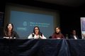
The meeting attended by representatives of 20 associations involved in disability issues on the island was chaired by the Ministers of the Presidency, Finance and Modernization and of Social Action, Berta Pérez and Marián Franquet, respectively, who highlighted that this first map on the The accessibility of the island’s urban centers and its main areas of tourist interest is only a “starting point” for work in which it is important to have the involvement of town halls and associations.
Along with them also participated the insular director of Modernization, Daniel González, and the person in charge of Accessibility of the Insular Society for the Promotion of People with Disabilities (Sinpromi), Dulce Torres.
Berta Pérez explained that through this project “information technologies are put at the service of people with disabilities, so that progress can be made to make Tenerife an accessible island both for people with disabilities and for those who have mobility or communication problems.
For her part, Marián Franquet highlighted that this first diagnosis, which collects information from the 31 municipalities of the island, “is a strategic tool to work in coordination with the municipalities and continue advancing in the achievement of accessibility.”
For this reason, he said, “we have met with the entities and associations that represent people with disabilities, so that they make their contributions, helping to identify and include all those situations that are not yet included on the map and achieve the highest degree of accessibility of the island”.
The meeting, held at the ONCE headquarters, was attended by representatives of this entity, as well as the associations Queremos Movernos; Mountain for All; CoordiCanarias; Funcasor; Parkinson Tenerife; acufade; Sonsoles Soriano Foundation; proboscus; sharpen; acaman; Prominsur; Adissur; press me; I want to be like you, help me; Associate Canary Islands; Orobal, Adacea; Aoten and Atelsam, pick up a note from the Cabildo.
ALMOST 2,000 HECTARES AND 661 KILOMETERS
The map, which was commissioned by the Presidency, Finance and Modernization area from Sinpromi, contemplates the analysis of a global urban area of 1,938 hectares and 661 kilometers of pedestrian routes.
Through it, it is possible to know the current state of the urban centers of the island’s municipalities as well as certain tourist areas and establish strategic lines of action, to promote their transformation and improvement, making it a basic instrument for management and project planning to improve accessibility throughout the island.
In addition, it offers information to residents and visitors on the accessibility of public places and places of tourist interest, through its implementation on public information platforms.
All the information can be consulted through the Grafcan public company viewer, https://visor.grafcan.es/visorweb/#in the insular tab, inside the Tenerife folder.
Furthermore, it is published in a reusable format in TenerifeData ( https://www.tenerifedata.com ) so that companies that wish to can download it and take advantage of it to enrich or launch new services.


")


")

