
Researchers from the University of La Laguna (ULL) have revived the urban landscape of The lagoon (Tenerife) at the end of the 16th century with a 3d model generated as a result of a collaboration between computer scientists, digital artists and historians from the academic center, with funding from the CajaCanarias Foundation and the collaboration of the consistory.
The digital reconstruction is the first to be created of the period and is based on the oldest plan of the city by the Italian engineer Leonardo Torriani, who lived there for different months between 1588 and 1589.
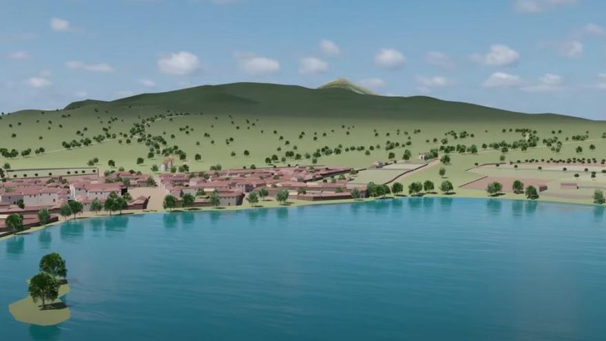
The plan details an urban layout that has remained since that time and which is, moreover, one of the justifications for the inscription of the city as a World Heritage Site, a layout that “has remained intact over the centuries, showing a relationship between colonial urban plots, characteristic of the city-territory concept, and Mudejar architecture”, the researchers explain.
Accompanying the map, Torriani highlights various characteristics of the city, and emphasizes that it is the largest and most inhabited of the islands, at that time. He describes it by pointing out that the more than a thousand houses that make it up each have a large garden space, full of orange trees and other beautiful trees.
From its surroundings, it stands out that, being at the top, “it has a lot of fog, with rains and very bad weather.”
This makes the houses seem low and gloomy from up close, but from a distance, looking from the height of some neighboring mountain, “the whole city looks good, because the streets are straight, the houses full of trees, and pleasant.” the lagoon”.
the people of the time
In relation to its inhabitants, he points out: “Justice and the council reside here, the rich noblemen and merchants from Spain, France, Flanders, England and Portugal, among them and the islanders, there are very rich people.”
The plan and description of the city have been the starting point for a project that has had to solve various difficulties, reports the ULL.
Practically no buildings survive without alterations from Torriani’s time, so it has been necessary to study the plotting and construction techniques of that time, the different types of houses, as well as their situation in the city according to the distribution of social classes. in the city and the importance of each street in the urban layout.
On the other hand, the unique buildings of the city only appear in plan on the map and there are no reliable descriptions of their appearance at that time, so they have had to be recreated using indirect documentary sources.
More than 1,000 houses and buildings recreated
The resulting 3D model is highly complex as the environment of the city, which occupies more than twenty square kilometres, has been digitally reconstructed.
Thus, the urban fabric of the time has been completely digitized, which survives in the city of the present, on which the more than a thousand houses that Torriani describes have been generated computationally.
Finally, all the unique buildings in the city have been recreated in 3D, including churches, convents, hermitages, public civil buildings or private houses, such as the Adelantado.
In addition, the latest technologies in character creation have been used to generate the inhabitants of the city by digitally reproducing the clothing of the time and digital clothing has been generated for the various social classes: nobility, clergy, merchants, artisans and peasants for both men as women and for various ages.
As a result, several applications and audiovisual material have been generated that can be consulted in the Web page.
Thus, it can be found from search engines to locate current addresses on the Torriani map, a museum of period clothing, videos with virtual tours of the city or 360 content for virtual reality glasses.
This type of 3D reconstruction and virtual reality applications is a tool that allows us to bring the history and heritage of our islands closer to its inhabitants and spread it worldwide.


")


