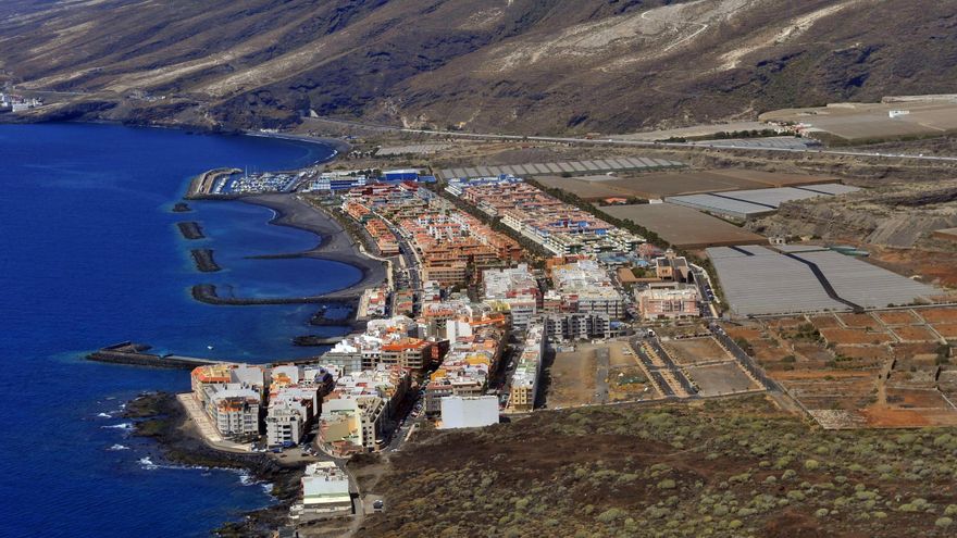
There was a time when this valley in the south-east of Tenerife was menceyato. Later, it became the setting for an image that would mark the Marian faith of the islands.
The name, of Amazigh origin, already present in 1498, has hardly changed and today baptises the municipality, a vivid memory of that past: Güímar. What is its exact meaning and how has it remained largely unchanged?
Several Theories
The chroniclers of the conquest recorded very different spellings, such as Aguímar, Agoymad, Goymad, Ygoymad… and so on, totalling twenty-two documented variants.
There are two main explanations regarding the origin of the toponym.
- The first, supported by the Historical-Etymological Dictionary of Insular Amazigh (ULPGC) and by philologists such as Maximiano Trapero, links it to the Berber word w-imar, “angle, corner, or nook“, a definition that fits with the shape of the valley: a geographical break wedged between Pedro Gil ridge to the north and Agache slope to the south.
- The second originates from ethnographers Juan Bethencourt Alfonso and Luis Diego Cuscoy, who collected oral traditions stating that the name means “the thrusts“, referring to an ancient battle or warrior rite held in the coastal plain of Chimisay, the place where centuries later the image of Our Lady of Candelaria would appear.
Although neither thesis is fully proven, both agree in emphasising the Guanche root of the term and its close connection to the orography and the military history of the territory.
Appearance of the Virgin
Around 1390, the shepherds of the area found a female wooden figure on the beach of Chimisay, which they called Chaxiraxi. That figure was first placed in the Cave of Chinguaro (upper valley) and later in the cave-añepa of Achbinico (currently Candelaria).
Centuries later, the Church identified that “divine” appearance as the Virgin of Candelaria and the episode turned the valley into the first Marian sanctuary in the Canaries, with a growing flow of pilgrims and offerings.
The Conquest
Before 1494, the valley that today forms the municipality of Güímar was one of the nine menceyatos into which Tenerife was divided. Its territory encompassed practically the entire south-eastern façade of the island: from the current Barranco del Hierro in the north to that of Herques in the south, and from the coast to the summit of Las Cañadas.
The mencey of Güímar, first Acaymo and, after his death, his son Añaterve, governed a group estimated to be between 3,000 and 4,000 inhabitants, according to calculations by archaeologists based on remains of housing and necropolises.
The valley had fluid relations with the nearby Abona (to the south) and Taoro (to the north).
Oral tradition describes it as a peaceful menceyato, and Añaterve was the first Guanche king to sign an alliance pact with Alonso Fernández de Lugo in 1494, acting as a mediator between the Castilians and the rebel factions.
When Lugo’s forces landed, Añaterve offered supplies, guides, and auxiliary soldiers in exchange for maintaining control over his pastures. Thanks to that alliance, the Castilians used the natural port of El Socorro as a logistical base and from there advanced to the north.
After the capitulation of 1496, the mencey received Christian baptism, irrigated lands, and the title of “noble knight”, integrating into the new administration.
After the Castilian annexation, the name was not lost. In the land distribution records, it is still referred to as “the whole term of Guymar.” Over time, the spelling was Hispanicised to Güímar, initially designating the valley and later the urban nucleus that is today the municipal capital.
Different Spellings
European writing attempted to reflect a sound alien to the Castilian alphabet: a u as a semi-consonant followed by i.
From this, transcriptions appear with o, y or even with two syllables (Gui-mad).
Only from the eighteenth century do maps begin to use the diaeresis to fix Güímar, a form accepted by the Royal Geographical Society in 1845.
The municipality concentrates the highest number of preserved Guanche voices in Tenerife: Chinguaro, Chacaica, Aguache, Chimaje, Tasagaya… More than twenty payments, ravines, or caves maintain intact the linguistic root of the menceyato, proving the demographic significance that the area held before 1496.


