
At around four-thirty in the afternoon this Sunday, DANA began to bid farewell to the Canary Islands with strong downpours in the southeast of Gran Canaria, in areas like Telde, Ingenio, and Agüimes, where within a short period of time, 29 litres per square metre were recorded, leading to the intervention of the emergency services from the Consorcio de Emergencias of Arinaga due to incidents where there were no serious damages reported.
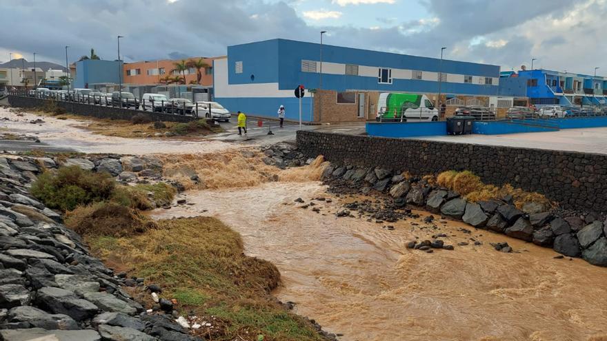
These short but intense rainstorms caused several ravines in the region to swell, such as El Burrero in Ingenio, the Silva ravine that flows into Salinetas, Telde, as well as the Ojos de Garza ravine in the same municipality, while firefighters worked on the flooded intersection of Las Majoreras and Las Puntillas in Carrizal, where two vehicles were left floating, as well as in four semi-basements scattered on Pinta street, located in the upper part of the urban area, and on Nicaragua street, in a service that lasted three hours of operations. Meanwhile, the emergency hotline received calls about flooded roads, landslides, and electrical network contingencies, and to a lesser extent alerts were received from Telde and Santa Brígida, as well as from Arrecife for similar issues.
[–>
This turned Sunday evening into a busy time, as experienced by Carmelo Santana, a resident of El Burrero, who had to use a mop to clear water from the gates, while describing how around five in the afternoon the sky collapsed with lightning and thunder over the sea, only to witness minutes later the bursting of several manholes and the sudden descent of water down the ravine, leaving a huge stain in the sea.
A similar situation was reported by Miguel Calzada, president of the neighbourhood association of Ojos de Garza, when around the same time “a torrent of water fell but with a swollen ravine“, after receiving 18 litres per square meter in the area in just a few minutes, resulting in a large puddle about 20 centimetres tall “due to some clogged drains“, blocking passage in the middle of the neighbourhood.
All this took place in the vicinity of Gran Canaria airport, which changed its operational direction from north to south, this combined with such adverse weather conditions causing delays of nearly an hour.
The alert continues
[–>
This follows a morning that on the island of Gran Canaria seemed to be calm, with even sunshine in many southeastern areas by midday, but the passage of another cloudy front from the west, where it wreaked havoc in the province of Santa Cruz de Tenerife, towards the east, forced the Government of the Canary Islands to maintain, in the early afternoon, a rainfall alert for the islands of Tenerife, Gran Canaria, Lanzarote and Fuerteventura.
An announcement made around four o’clock, half an hour before the rainfall intensified in the southeast, while in other locations just a few kilometres away, not a drop fell.
Thus ends a spell of instability that has broken a streak of months without significant precipitation in the southern half of Gran Canaria, with Aemet forecasting a Monday without active alerts, but still with aftermath of cloudy skies in the northern slopes, with possible occasional rain during the first half of the day, especially on the islands of Gran Canaria, Fuerteventura, Lanzarote, and La Graciosa. Additionally, minimum temperatures will rise slightly, with maximums remaining relatively unchanged in the north, recording values between 18 and 23 degrees Celsius in the two Canary capitals.
More rain for Thursday
[–>
For Tuesday, yellow alerts are indeed issued for coastal phenomena in the islands of La Gomera and Tenerife, setting the stage for overcast skies in the northern slopes, not ruling out rain accompanied by a northerly wind with occasional strong gusts in the most exposed areas to the trade winds, leading into a Wednesday with less chance of rain and slightly rising temperatures in the northern midlands.
[–>
It will be Thursday when a band of precipitation is expected to move again from west to east of the archipelago, with rain in La Palma in the early afternoon, initiating rains across the rest of the archipelago as the day progresses, with maximum temperatures rising and an occasionally strong westerly wind in the western islands by the afternoon.


")


")

