
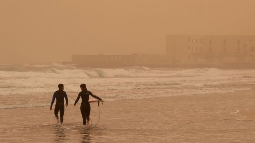
A high-pressure system over the Peninsula and a weak storm southwest of the Canary Islands. These are the unusual ingredients that, during winter, can generate winds strong enough to carry large amounts of suspended dust to the archipelago and the Peninsula. The strange supercalimas that tinted the skies and snow in ochre between 2020 and 2022 were the result of an atmospheric pattern never seen before – at least not in the last 20 years of recording. A disposition that also resembles atmospheric configurations that had been predicted on a planet in turmoil due to climate change.
This is the conclusion reached by a study conducted by researchers in the Canary Islands and is currently under review in the journal Atmospheric Chemistry and Physics. The study is led by the scientist from the Institute of Natural Products and Agrobiology (IPNA-CSIC), Sergio Rodríguez, who comes to this conclusion after reconstructing the data on concentrations of breathable particles, less than 10 microns (PM10) during the six supercalima episodes that have affected the Canary Islands and the Peninsula in those three unusual years.
The episodes that have been studied are those in which concentrations of particles smaller than 10 microns (the so-called PM10) exceeded 1,000 micrograms per cubic meter: from February 3 to 5, 2020, from February 22 to 29, 2020 (commonly known as the carnival supercalima), from February 15 to 21, 2021; from January 14 to 17, 2022; from January 29 to February 1, 2022, and from March 14 to 20, 2022.
The study concludes that the origin of these extraordinary episodes lies in a peculiar winter battle between high and low-pressure systems located in unusual places for the season. An “anomalous” situation that is also supported by other studies that have tried to analyse what has been happening in the atmosphere in recent years to cause extraordinary situations like these massive entries of suspended dust both to the Canary Islands and the European continent.
One of the reasons why supercalimas have become more recurrent visitors to the archipelago and Europe is the displacement of the subtropical high-pressure system of the North Atlantic. “During the months of January and February, from 2020 to this year 2024, it has shifted from being located south of the Azores to being positioned in the south of the Iberian Peninsula,” summarizes Rodríguez.
The study succeeds in reconstructing data from six intense suspended dust episodes
[–>
This blocking situation diverts the storms to a much more distant place, the southwest of the Canary Islands or even over the islands. The interaction between storms and the large high-pressure system – in a configuration that researchers call a dipole – is what produces the “intense winds blowing from east to west” that ultimately carry Saharan dust to unsuspected places. “They are like two wheels of the same gear that generate a synergy and intensify this phenomenon,” notes the researcher.
This battle in the skies is what has brought about the supercalimas, events so extraordinary that in the Canary Islands there are no similar records in any year since 2005. “And in the records of Izaña, which start in 1987, neither has a similar amount of dust been perceived to what was recorded in that carnival week of February 2020,” Rodríguez concludes.
“The concentrations of breathable particles PM10 during those days were so high that the measuring instruments saturated at 999 micrograms of suspended dust per cubic meter of air,” says the researcher from IPNA-CSIC. This means that initially, the equipment would not have been able to properly measure such high dust concentrations, so a new method had to be devised to thoroughly understand what happened during those days.
As a result of this issue, the researcher set out to create a data reconstruction method that, three years later, has allowed to know exactly how much calima reached the Canary Islands and the Peninsula on those days when dust clouds engulfed everything in their path. “The concentrations are unbelievably high,” Rodríguez remarks. This is how it has been possible to establish, for example, that “between March 15 and 17, 2022 in Almería, hourly concentrations of almost 6,000 micrograms per cubic meter were reached.”
On the other hand, in February 2020, in areas such as Arinaga, Gran Canaria, hourly averages reached 5254 micrograms per cubic meter and a daily average of 1,840 micrograms per cubic meter in the south of Tenerife, a value 40 times higher than the concentrations recommended by the World Health Organization (WHO), which is at 45 micrograms per cubic meter daily.
Air Quality Laboratory
To better control and understand these phenomena, the Canary Islands are creating the first comprehensive chemical analysis observatory of calimas in Europe. The Government of the Canary Islands, through the Ministry of Ecological Transition and Energy, Fight against Climate Change, and Territorial Planning, and the Institute of Natural Products and Agrobiology (IPNA-CSIC) have created the Air Quality Laboratory of the Canary Islands, a new and unique infrastructure that aims to “quantify the components of the particles” found in the air breathed by the Canarian population.
The Air Quality Laboratory of the Canary Islands will analyse the chemical composition of the calimas
[–>
One of the main goals of this laboratory, which is already installing several stations in the Islands, will be to quantify the sources of the different particles that make up air pollution in the Canaries. Determining the contribution of each pollutant will, in turn, help identify where measures can be taken to reduce their impact on worsening air quality.
[–>
This project is already setting up monitors at different points in the Islands. Especially in strategic locations such as the south of Tenerife, Gran Canaria, and Fuerteventura, as well as some areas in Lanzarote and the north of the Islands. In the first phase of the network deployment, measurement equipment has been installed in La Graciosa, Puerto del Rosario (Fuerteventura), Las Palmas de Gran Canaria and Santa Cruz de Tenerife. In a second phase, more monitors will be installed to complete the observation of this phenomenon so common in the Archipelago.
Yellow warning in Lanzarote and Fuerteventura
The State Meteorological Agency (Aemet) has issued a yellow warning for calima on the islands of Lanzarote and Fuerteventura this Sunday, between 12.00 and 21.00 hours, and significant reductions in visibility are not ruled out, up to 3,000 meters. Meanwhile, temperatures continue to rise throughout the Archipelago, and yesterday Saturday reached 33.4 degrees in the town of La Oliva in Fuerteventura. This was followed by 32.4 degrees in Tasarte (La Aldea), 32.3 in Antigua, and 31.8 in Tinajo. The General Directorate of Emergencies of the Government of the Canary Islands has declared a pre-alert situation due to the new calima episode, which could also affect the midlands, mountain tops, and southern slopes of the rest of the islands. Given the possibility that this episode could affect particularly those with chronic or respiratory diseases, the population is advised to take appropriate self-protection measures, such as ensuring their medication, keeping doors and windows closed, and avoiding going outside. | LP/DLP
[–>


")


