
SANTA CRUZ DE TENERIFE, 29th February (EUROPE PRESS) –
A dedicated group of researchers from the University of La Laguna (Geoturvol) have recently published a scientific piece in the International Geophysics journal from the Autonomous University of Mexico. Their study focuses on the discovery of 16 fascinating geotourism spots after the Tajogaite volcano eruption.
The research highlights the identification, selection, characterization, and evaluation of geomorphosites of significant geotourism interest. These sites showcase the natural and cultural heritage linked to both the pre-eruption landscape impacted by the volcano and the new landscape that emerged afterwards. These locations can be visited physically or virtually, aligning with the accessible tourism principle advocated by the World Tourism Organization.
The incredible volcanic eruption on La Palma in 2021 drew countless visitors while unfolding, with its diverse volcanic and non-volcanic formations and processes attracting tourists to the island. The range of relief forms and processes resulting directly from the eruption, as well as the geographical heritage (both natural and cultural) that existed before but was altered by the volcanic materials expelled, serve as remarkable examples of geomorphosites with great potential for geotourism.
The publication is authored by Javier Dóniz Páez, who leads Geoturvol at the University of La Laguna and is a researcher at Involcan; alongside Rafael Becerra Ramírez, Rafael U. Gosálvez, and Estela Escobar from the Geovol group at the University of Castilla-La Mancha, who are scientific collaborators from Involcan; as well as Karoly Németh from Massey University (New Zealand).
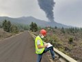
Fieldwork was crucial in compiling the catalog of geomorphosites with geotourism interest. This involved on-site visits during the eruption in 2021, as well as explorations post-eruption in 2022 and 2023. The team captured numerous photographs, conducted drone surveys, and most importantly, ventured to different accessible locations.
Following selection, a semi-quantitative methodology for evaluating geoheritage was applied, considering scientific, additional, and utilization values. This method aids in determining the appropriate level of utilization for each chosen geomorphosite in line with preserving their heritage values.
One of the key challenges faced during fieldwork was the inaccessibility of certain selected sites due to high temperatures and hazardous gas concentrations. Consequently, recordings were utilized to apply the evaluation methodology.
GEOMORPHOSITES CATALOGUE
Sixteen geomorphosites closely or indirectly linked to the Tajogaite volcano have been meticulously studied. Among them, six locations were formed during the eruption (Tajogaite volcano cone, hornitos, eruptive fissures, pahoehoe lavas, ‘A’a lavas, and lava delta), while the remaining ten represent the natural and rural heritage pre-eruption (Montaña Rajada, Montaña Cogote, Todoque Mountain, La Laguna Mountain, Tacande Viewpoints, Campitos, Tajuya, San Isidro, La Hoya, and La Bombilla).
In a general sense, the six geomorphosites directly related to the Tajogaite eruption and Montaña Rajada display higher scientific evaluations than additional values, indicating a need for more stringent tourist regulations compared to the nine sites chosen before the eruption, where added values surpass scientific ones. Currently, seven out of the sixteen locations are inaccessible, while the others can be visited in person, shaping the real or virtual nature of the geoitinerary devised by relevant authorities and active tourism companies.
Each of the selected geomorphosites epitomizes the volcanic heritage post-eruption, pre-eruption, and the amalgamation of both. The research team believes that these 16 sites encapsulate the diverse allure of volcanic tourism.
The study leading to this publication was funded by the VOLTURMAC project spearheaded by the Volcanological Institute of the Canary Islands (Involcan), and by the seventh goal of the La Palma Territorial Recovery Project overseen by Involcan, commissioned by the General Administration of the State, the Ministry of Science and Innovation, the Ministry of Ecological Transition and Demographic Challenge, and the Ministry of Ecological Transition, Fight Against Climate Change and Territorial Planning of the Government of the Canary Islands-GESPLAN (year 2022).


")


