
SANTA CRUZ DE TENERIFE, Oct. 20 (EUROPA PRESS) –
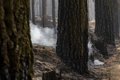
The volcanic soils of the Canary Islands are especially susceptible to the occurrence of large-scale runoff and erosion events after forest fires.
This is revealed by various studies developed since 2015 by the Area of Soil Science and Agricultural Chemistry of the University of La Laguna, in collaboration with the councils of Tenerife and Gran Canaria, the Government of the Canary Islands and other research institutions such as the Center for Research of Bushfires at Swansea University (UK), the US Forest Service and the University of Melbourne (Australia).
This series of studies has addressed the effect of forest fires on runoff, erosion and the occurrence of floods and land movements in all types of terrain and, in particular, in volcanic soils.
The field work, funded by the EU and the United Kingdom Ministry of the Environment, has been carried out in the US, the United Kingdom, Australia and the Canary Islands after the 2015 and 2018 fires in Tenerife (Altos de Arafo and Vilaflor and Madre del Agua) and in Gran Canaria (Artenara 2019), includes a note from the ULL.
This proclivity for runoff and erosion is especially true in northern areas of the islands where climatological conditions allow the development of very deep soils that, in many cases, are found in areas of high slope.
In fact, the impact of fire in these areas is usually severe, which increases the risk of floods and drifts.
To give an example, after the Artenara fire in 2019, up to six tons of haulage (soil and stones) were quantified in the most humid areas affected by the fire.
One of the researchers at the University of La Laguna responsible for these studies, Jonay Neris Tomé, explains that, although the most notable effect of fires is their direct impact on the vegetation, there are others that can be seen even years later and, in some cases, in areas that have not been affected by the fire.
From the ULL they point out that this is the case of the increase in the aforementioned runoff and erosion processes and the subsequent floods and drifts in which a large amount of soil is transported.
Recent events in areas affected by forest fires have shown that these events, in conjunction with extreme rainfall, can have severe consequences on the infrastructure and the population located downstream of an area affected by forest fires in the years following the fire.
This is especially true in volcanic areas, where the characteristics of the geology (volcanic rocks) together with the climatic conditions and vegetation of the area allow the development of very deep soils even in areas of high slope, such as the soils of the Canarian mountains.
These soils, although they are very fertile and stable under natural conditions, are very unstable after being affected by fire both due to their depth conditions and their location in areas of high inclination.
EARTH MOVEMENTS AFTER THE LA PALMA FIRE IN 2019
The expert cites, for example, that after the great fire of La Palma in 2009 and during the torrential rains in December of that year, there were large movements of earth from the slopes affected by the fire that produced cuts and even collapse of roads and affected several homes and farming areas on the coast when the fire broke out at about 800 meters above sea level.
Similar events had already been described on the island in 1973, 1979 and 1990 and in 2020, after a small fire in Tenerife, landslides occurred on the TF-5 highway that forced the closure of a road with a traffic intensity of 40,000 vehicles a day.
The direct and indirect costs derived from these floods and hauls, both for the restitution of infrastructure and the application of measures to reduce risks of runoff and erosion, are usually large: the budget for restitution of infrastructure after the 2009 fire in La Palma and the subsequent flood amounted to 8 million euros.
After the great Tenerife fire of 2007, the budget for the application of risk reduction measures amounted to 7 million and in the case of the Tenerife fire in 2023, which has not yet been declared extinct and already affects 14,000 hectares, It is estimated that it will amount to 30 million in three years, including forestry work in the area affected by the fire.
Post-fire management includes the application of measures to control runoff and erosion on fire-affected slopes to reduce the risk of floods and drifts.
Along these lines, the University of La Laguna, together with the councils of Tenerife and Gran Canaria and the Government of the Canary Islands, has carried out studies on the effectiveness of different methods for control after fires.
USE OF CHIPS AND PINOCHCHA
These studies have provided information on the effectiveness of the control methods currently used (mainly fascines) and have made it possible to propose the use of alternative methods that are highly effective in reducing runoff and erosion, such as the use of chips obtained from burned plant material, or pine needles as soil cover to improve infiltration and reduce runoff and soil transport, recommended in certain scenarios.
The results obtained have also allowed the adaptation of the WEPPcloud runoff and erosion prediction model, developed by the US Forest Service, for Tenerife and, soon, the rest of the islands.
This model, freely accessible and designed for forest managers, allows predicting the probability of occurrence and magnitude of runoff and erosion phenomena in basins affected by forest fires.
Currently, the Soil Science and Agricultural Chemistry Area of the academic institution collaborates with technicians from the Cabildo of Tenerife to design measures to control runoff and erosion in the areas affected by the recent Arafo fire in 2023, using the results of this model.


