
SANTA CRUZ DE TENERIFE, September 14 (EUROPA PRESS) –
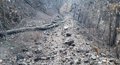
The Cabildo of Tenerife continues working to prevent the reproduction of the forest fire, whose perimeter is about 90 kilometers, and remembers that it is prohibited to travel on the tracks and trails affected by the fire.
The island corporation maintains the Territorial Island Emergency Plan (PEIN) activated and has adopted a series of measures that remain in force.
Thus, the prohibition of travel in the area affected by the fire is maintained in the municipalities of Fasnia, Güímar, Arafo, Candelaria, El Rosario, Tacoronte, El Sauzal, La Matanza de Acentejo, La Victoria de Acentejo, Santa Úrsula, La Orotava and Los Realejos.
The Minister of the Natural Environment, Blanca Pérez, points out in a note that “the fire has not ended and reactivations continue to occur within the perimeter.”
Furthermore, it indicates that the measures that have been established have been done to “ensure the safety of people, both the general population and the workers who are involved in extinguishing work, removing material from the slopes and trails. and in restoration tasks”.
Along these lines, he points out that “it is dangerous to travel on the trails and tracks affected by the fire” and that is why the prohibition is maintained. “Our priority is people’s safety,” he details.
In addition to not being able to travel on the slopes and trails, the prohibition on the use of fire outdoors (bonfires, stoves, barbecues, gas stoves) and pyrotechnic displays is maintained in the area located within the Corona Forestal Natural Park of the municipalities affected by the fire.
In the rest of the areas of the municipalities affected by the fire, the use of machinery and tools is permitted, although extreme caution is requested when using them. Likewise, hunting activity is allowed.
Access to the Teide National Park is still closed through the TF-24 (La Esperanza) and TF-21 (La Orotava) and can be done through Vilaflor (TF-21) and Chío (TF-38). The cutoff point is located in Portillo Alto so that people can access the restaurants located in the area.
The TF-523 highway (Subida Los Loros) also remains closed. However, the cutoff points of the TF-21 (La Orotava) and TF-523 (Subida Los Loros) have been modified in order to facilitate access to the farms.
Thus, in the TF-21 the cut-off point is located at the station. 16+500, at the height of La Caldera, where the barrier that prevents passage will be placed and on the TF-523 highway (Subida Los Loros) the cut is located at the KP. 13+500 between 8:00 a.m. and 8:00 p.m. (daytime).
At night the cut will be located at the PK. 10+100, where the barrier will be placed to prevent the passage of vehicles.
CLOSED RECREATIONAL AREAS
In addition, the following recreational areas and camping areas are temporarily closed: Chanajiga (Los Realejos), Hoya del Abade (La Victoria), La Caldera (La Orotava), La Laguneta Chica (Santa Úrsula), Las Calderetas (El Sauzal) , Las Raíces (El Rosario), Lomo La Jara (Tacoronte), Los Frailes (Arafo) and Ramón El Caminero (La Orotava).
As for the trails of the Teide National Park, the following are completely closed: Trail No. 1 La Fortaleza, Trail No. 2 Arenas Negras, Trail No. 8 El Filo, Trail No. 14 Alto de Guamaso, Trail No. 17 Igueque, Trail no. 20 Fasnia Volcano, Trail no. 21 Corral del Niño to La Yegua Blanca, Trail no. Butcher shop.
For its part, Trail No. 4 Siete Cañadas is partially closed from the beginning by the El Portillo Visitor Center until its contact with Trail No. 30 Los Valles (Risco de La Papelera), while Trail No. 22 Lomo Hurtado is partially closed. closed from the beginning in contact with trail nº1 La Fortaleza until its contact with trail nº33 Montaña Negra).


")

")


