
SANTA CRUZ DE TENERIFE, Aug. 31 (EUROPA PRESS) –
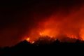
The College of Registrars of Spain has estimated the impact of the Tenerife forest fire on an area of 15,915.44 hectares, 364 farms and 246 buildings or constructions, most of them agricultural in nature, according to data obtained through its Registry Portal. Emergencies (PRE), which crosses its own data with the European Copernicus satellite system.
The fire has affected 33 registered properties and 20 buildings in Santa Cruz de Tenerife; 111 farms and 33 buildings in Tacoronte; 12 farms and 6 buildings in El Rosario; 43 farms and 11 buildings in Güímar and 165 farms and 176 buildings in La Orotava, the municipality most damaged by the incident.
From the College they point out in a note that the Emergency Registry Portal (https://geoportal.registradores.org/emergency) is an open and public tool through which affected citizens can check, based on the location of their farm or property, if it has been affected by the fire and directly request the registry information through a simple informative note to the competent registry.
Along these lines, it stands out that in recent months improvements have been implemented in the PRE, which will provide users and administrations, among other issues, with a pre-emergency registry that includes the location of properties through the cadastral reference, the registry code. unique CRU, or the street and municipality number.


")


