
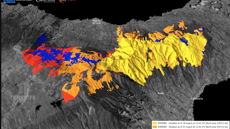
The European satellite system Copernicus has raised to 12,273 hectares the area burned by the fire forestry of Tenerife declared on August 15 in its latest update.
There are 1,316 hectares more than those estimated last Friday and make it the worst fire in the Canary Islands in the last 40 years.
This new burned area corresponds mainly to the Valley of La Orotava, as can be seen on the map published by Copernicus.
The area affected by the flames in the Tenerife fire exceeds 14,000 hectares in a perimeter of 90 kilometers.
The #IFArafoCandelaria in #Tenerife 🇪🇸 has affected 12,273 ha and two protected areas, and continues to impact the local air quality
⬇️Analysis of the evolution of the burnt area🔥provided by the @CopernicusEMS #RapidMappingTeam under the #EMSR685 activation pic.twitter.com/Bh75lzTMwB
— Copernicus EU (@CopernicusEU) August 28, 2023
The work of the firefighting operation continues to be very hard and on Sunday there were reactivations that forced the evacuation of seven homes.
The Tenerife forest fire has been in the stabilization phase since August 24, which means that it is evolving within the established control lines, according to forecasts, and that extinction efforts are directed towards its control.


")


