
He Canary archipelago lives the last throes of the red warning for high temperatures. After almost a week with the thermometers exceeding the highest in the country, the situation will begin to stabilize in the coming days, so that during the weekend, the heat will return with force.
After the death on Friday due to high temperatures of a neighbor from fatagain San Bartolome de Tirajana, the first victim of this heat wave, the second was found yesterday in a mountain area of Morro Jable, in the municipality of Pájara, Majorero. The victim, a 39-year-old woman, was wearing sportswear, because her death is attributed to heat stroke. The staff of the Canary Emergency Service (SUC) confirmed upon arrival that the person was already deceased.
In addition, at six in the afternoon, in the municipality of Guide of Isora, in Tenerife, the third fatality of this heat wave. This is another woman, this 50-year-old Dutch national, who was hiking in a ravine in the Vera de Erques area. It is considered that it could be a heat stroke, since the victim fainted while she was practicing sports. All this, in a framework in which the Aemet recommended not to carry out any outdoor sports activity due to the alert for maximum temperatures on the islands.
According to the State Meteorological Agency (Aemet), the extreme heat will give the archipelago a break today, where the heat is expected to subsidewith falling temperatures and reducing the presence of hazewhich will subside slightly.
Sunday’s day stood out for registering, for the second consecutive day, the highest in the country in appraise you with a temperature of 44.4 degrees at 3:20 p.m. The third, fourth and fifth of the Spanish territory, also registered it Gran Canaria in Lomo Pedro Alfonso (43.7 at 4:50 p.m.), Las Tirajanas (42.5 at 2:40 p.m.) and Agüimes (40.8 at 10.00).
In addition, the sensation of heat increased notably due to the haze and the mass of warm, dry air. For this reason, visibility was even reduced by around three kilometers, mainly affecting the higher areas of the islands with greater relief.
However, the red warnings for high temperatures ended yesterday afternoon, while the yellow warning will be present throughout the day today and tomorrow in the palm island, La Gomera, The iron Tenerife and Gran Canaria. For this last island, the warning will be orange between eleven in the morning and six in the afternoon today, hours in which temperatures are expected to rise to their maximum peak.

The predictions forecast for today, as shown by Aemet, are mostly cloudless or clear skies, except for some intervals of low clouds on the northern coasts of the islands with greater relief in the early and late hours.
Temperatures that will drop moderately, although they may reach 35 to 37 degrees in the middle of the islands with higher relief, especially those facing south and west, and may even exceed 38 degrees in these areas. As for the minimum temperatures, it is expected that they will be between 25 or 27 degrees Celsius in a timely manner on the islands of greater relief. The winds will be from the northeast with strong intervals on the southeast and northwest slopes.
On the other hand, the yellow warning for suspended dust will be deactivated today. Regarding the wind, it will be from the northeast, with strong intervals and a low probability of occasional very strong gusts on the southeast and northwest slopes, as well as on the west tip. It will be less intense in summits. Breezes on the southwest coast.
Regarding warnings due to rough seas, AEMET maintains the yellow warning on the west and southeast coast of Gran Canaria, mainly offshore. This notice will remain in effect until next Tuesday. A worrying warning that requires extreme precautions when cooling off under the sea.
In this way, the forecast indicates that during this next week, the thermometers will drop during the weekend, gain momentum and rise again. A few days ago, it was Aemet that was forced to change the alert levels twice, until leaving them red due to heat on all the islands except Lanzarote. A surprising situation, since it was the first time that the red warning for high temperatures was activated on six islands of the Canary archipelago.
On the other hand, in the August bank holiday in the rest of Spain, the heat, storms, rainfall and coastal phenomena are activated in 14 provinces, while the maximum temperatures will increase in areas of the Mediterranean and Asturias.
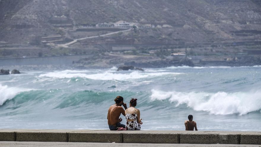
Strong swell hit Tenerife hardest
The sea showed all its strength over the weekend off the coast of Tenerifealthough it was also felt in Gran Canaria and Fuerteventura. For the second day in a row, the waves forced the closure of several roads on the coast of the municipality of Arona, the placing of the red flag on the beaches of El Rosario and the change of operating base to Naviera Armas from Los Cristianos to Santa Cruz due to the strong surf in the southern port. Despite the yellow warning for coastal phenomena, the bathers who went to Radazul experienced moments of tension. Some had trouble getting out of the water and one of them was even dragged by the wave when he was trying to get out of the breakwater. Similar trouble situations were seen in La Nea and Tabaiba. Regarding the change of route of Naviera Armas, which had to reorganize the schedule, it is expected that it will be today, as long as the weather conditions allow it, when operations with the port of Los Cristianos will resume. The company advises those planning to travel today to contact 902 456 500. | JDM


