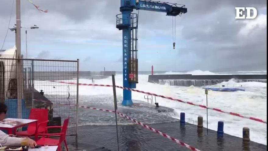
The last day of the month of February is not propitious to approach the coasts in Canary Islands. The waves will reach between 3 and 4 meters high this Tuesday, February 28according to the weather forecast in the Canary Islands from the State Meteorological Agency (Aemet).
The General Directorate of Security and Emergencies of the Government of the Canary Islands has declared the pre-alert for coastal phenomena in the Canary Islandswhich will be in force from 9:00 a.m. on Tuesday per episode of rough seas with a northerly wind and force 3-4. Likewise, a northwesterly swell is expected with combined sea that will produce waves of between 3 and 4.5 meters.
Tidal wave to tidal wave, which will especially affect El Hierro, La Gomera, the north and west coast of La Palma and Tenerife, the north coast of Gran Canaria and the north and west coast of Fuerteventura, Lanzarote and La Graciosa.
Weather forecast by islands for Tuesday in the Canary Islands
In Lanzarote, Fuerteventura and to the north of the islands of greater relief, cloudy intervals with a predominance of clear ones at the beginning. In the rest of the areas, little cloudiness tending to cloudy intervals due to evolutionary cloudiness during the central hours of the day.
Maximum temperatures slightly rising in inland areas, with few changes on the coasts. The minimum, with few changes or with some slight ascent.
Wind with a predominance of the northern component, weak in the western islands and moderate in the eastern ones.
TENERIFE
Little cloudy in general at the beginning with some interval on the coasts. From noon it will increase to cloudy intervals, especially in inland areas to the south with the formation of evolution clouds that, with little probability, could be accompanied by weak precipitation. Minimum temperatures with few changes, the maximum slightly rising, something more pronounced in high areas. Loose north component wind in general. Breezes on north and south coasts.
FORECAST MINIMUM AND MAXIMUM TEMPERATURES (°C):
Santa Cruz de Tenerife 16 23
LA GOMERA
In the north, cloudy intervals with a predominance of clear ones in the afternoon and cloudy skies at the end. In the rest, little cloudy tending to intervals due to cloudiness of evolution in the afternoon. Temperatures without changes or slightly rising, mainly the maximum. Loose wind with a predominance of the northeast. Coastal breezes.
FORECAST MINIMUM AND MAXIMUM TEMPERATURES (°C):
San Sebastian de La Gomera 16 23
THE PALM
Little cloudy in general at the beginning with some interval on the coasts. Starting at noon it will increase to cloudy intervals, especially on the southern and western slopes with the formation of evolutionary clouds. In the end it will increase to cloudy also on the north slope. Temperatures unchanged or slightly rising. Loose wind with a predominance of the northeast. Coastal breezes.
FORECAST MINIMUM AND MAXIMUM TEMPERATURES (°C):
Santa Cruz de La Palma 16 22
THE IRON
In the north, cloudy intervals with a predominance of clearing at the beginning. In the rest, little cloudy tending to intervals due to cloudiness of evolution in the afternoon. Temperatures unchanged or slightly rising. Loose wind in general with a predominance of the northeast. Coastal breezes.
FORECAST MINIMUM AND MAXIMUM TEMPERATURES (°C):
Valverde 13 18
LANZAROTE
Cloudy intervals with a predominance of cloudy skies during the central hours of the day, when some weak, occasional and scattered rain cannot be ruled out. Maximum temperatures with few changes and minimums with a slight rise. Moderate wind from the north component, more intense in inland areas.
FORECAST MINIMUM AND MAXIMUM TEMPERATURES (°C):
reef 16 24
Fuerteventura
Cloudy intervals with a predominance of cloudy skies during the central hours of the day. Maximum temperatures with few changes and minimums with a slight rise. Moderate wind from the north, more intense in inland areas and to the south of the Jandía peninsula.
FORECAST MINIMUM AND MAXIMUM TEMPERATURES (°C):
Puerto del Rosario 16 24
GRAND CANARY
In the north, cloudy intervals with a predominance of cloudy skies at the end, when some weak, occasional and scattered precipitation is not ruled out, mainly in the midlands. In the rest, little cloudy tending to intervals due to cloudiness of evolution in the afternoon. Minimum temperatures with few changes, the maximum slightly rising in inland areas. Light to moderate wind from the north component, with strong intervals on the southeast and northwest slopes. Breezes on south and north coasts.
FORECAST MINIMUM AND MAXIMUM TEMPERATURES (°C):
Las Palmas de Gran Canaria 16 22


