
SANTA CRUZ DE TENERIFE, Oct. 13 (EUROPA PRESS) –
The emission of sulfur dioxide (SO2) associated with the volcanic plume (visible emanations) on the island of La Palma continues to register high values in line with the eruptive process, reaching values of 17,774 tons per day (underestimated value) yesterday, which which indicates that the end of the eruption will not occur “in the short or medium term.”
This has been indicated by the spokesperson for the Pevolca Scientific Committee and director of the National Geographic Institute (IGN) in the Canary Islands, María José Blanco, who recalled that several parameters are used to calculate the end of an eruption, such as the SO2 emission rate. , which would have to be 100 tons per day, and even less, the deformation and the level of seismicity, parameters that currently do not meet the requirements to be able to say that the end of the eruption is near.
With regard to the wash that is advancing towards the northwest and that yesterday forced the preventive evacuation in new areas of La Laguna, in the municipality of Los Llanos, the technical director of Pevolca, Miguel Ángel Morcuende, has reported that it is progressing “very slowly “and right now it is” losing steam “in relation to the melt that is located slightly more to the south, that is moving at more speed (about 50 meters per hour) and is accumulating the maximum of energy and thrust from the center of transmitter.
Miguel Ángel Morcuende has specified that the wash moving towards the northwest is not yet close to the evacuated area and advanced that if everything continues as before, it is possible that it “aborts” and “does not walk again.” The Pevolca will continue throughout this afternoon monitoring and watching over this wash to see if it finally stops.
The area affected by the lava until yesterday Tuesday stood at 640.27 hectares, which is 27.94 more than the previous day, and the maximum width of the wash is 1,770 meters, 250 meters more, due to the widening caused by the laundry coming from the northwest.
According to data from the Copernicus satellite, a total of 1,541 buildings / constructions have been affected by the lava, of which 1,408 have been destroyed and 83 are at risk. For its part, the Cadastre data indicates that there are 937 effective buildings affected, of which 763 are for residential use, 83 for agricultural use, 45 for industrial use, 22 for leisure and hospitality and 18 for public use and others.
In addition, there are 280 people housed in the Princess Hotel in Fuencaliente and the number of evacuees remains at around 6,000 people, of which most are housed in second homes or with family or friends. Also, of the people who were evacuated yesterday, there were 9 with reduced mobility who have been housed in establishments such as the Hospital de Dolores.
A SAFE ISLAND.
The technical director of Pevolca has once again insisted that the impact of the island’s surface by the volcano is approximately 8%, which means that there is 92% of the territory that is not directly affected or that the condition is minor. For this reason, he reiterated that La Palma is “a safe island” and that, except in the Aridane Valley, in the rest “life passes normally”.
He also wanted to make it clear that the fish that is slaughtered on the island and that is available to its inhabitants is “quality fish, the same as there was before the volcano erupted.” In addition, it has shown that La Palma is “an absolutely stable island”, so “there is no phenomenon that allows us to ensure that the island may have an undesirable situation in terms of geological stability at any given time”.
Miguel Ángel Morcuende has highlighted the importance of transferring this idea of normality and that La Palma “is safe, stable and activities such as tourism and others can be developed”, and that “there are lots of people who depend on these activities, so that a bad knowledge of the situation causes these people to get into financial trouble. “
Similarly, he repeated again that La Palma Airport is also operating with “absolute normality” and only has problems when there is a west wind, which blows all the ash on the runway.
With regard to seismicity, it was noted that the seismic swarm is located slightly to the south and east of where the initial swarm that gave rise to the eruption was. In this sense, he remarked that at the depths at which the earthquakes are occurring, without visible deformations in other parts of the island and with a stabilized deformation in the vicinity of the cone, without fumaroles that denounce another probable danger in other areas of the island , indicate that there is a “low probability” that there are other emission centers in places other than the vicinity of the cone.
DAILY OPINION OF THE SCIENTIFIC COMMITTEE
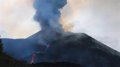
According to the daily opinion of the Pevolca Scientific Committee, the fissure eruption continues to show a strombolian mechanism and the Volcanic Explosivity Index (VEI) remains at 2.
The main flow of the lava flows runs along the north flank, down the northern part of the previous flows, following trajectories towards the west and northwest, within the current exclusion zone. The distance from the front of this lava flow to the sea is of the order of 200 m.
Large blocks dragged by the lava flow further north continue to be observed and the emission centers of the crater are still active and the reactivation of one of the southeast flanks of the main cone is confirmed. The appearance of new emission centers around the main cone, as well as other surface observables (visible gas emissions) within the exclusion zone, is not ruled out.
The front of the lava delta (fajana) continues practically inactive. The estimate of the total volume emitted until day 10 of the dispersion pyroclast is between 8 and 9 million m3.
The morphology of the cone changes repeatedly due to the successive processes of growth and reconfiguration. The eruptive process can show episodes of increased and decreased strombolian activity, as well as pulses with phreatomagmatic activity. The height of the ash and gas column measured today, as well as its dispersion, reaches 3,000 meters.
The weak wind is expected to continue and in the next few hours the wind will turn from north to east at levels between 1,500 to 4,000 meters. The expected arrangement of the ash cloud and sulfur dioxide (SO2) will be to the west from the eruptive focus, so the areas most affected by the ash fall will be the west and south of La Palma. The expected disposition of the plume is favorable for the activity of the Canarian airports and the forecast meteorological conditions are favorable from the point of view of air quality. As of days 15 and 16, the entry of a dry continental air mass is expected that will collapse the height of the base of the thermal inversion and will make it more pronounced, so that the meteorological conditions would be unfavorable from the point of view. of air quality.
Seismicity continues to be located, mainly, close to the seismicity of the first days, at depths between 10 and 15 km. There are also earthquakes located at depths greater than 20 km. In the last 24 hours the amplitude of the tremor signal has increased. The maximum magnitude observed was 3.9 mbLg and the maximum intensity was III-IV EMS. The current level of seismicity continues to indicate that more felt earthquakes are possible, which could cause small landslides in sloping areas. The deformations at the stations closest to the eruptive center do not show any significant pattern.


")


